| Return to Homepage | Photo Journal: Northern Brazil, Amazon, Central Brazil |
|
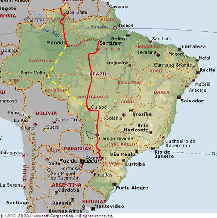
The red line is the route we have cycled. The dashed yellow line is another route option we considered. The route between Manaus and Porto Velho would have been along a road which has been closed to vehicles since 1992, although we had heard that it may be possible for bicycles and motorbikes to travel it using small boats to cross rivers where bridges have collapsed. However, on arrival in Manaus water levels were high and local advice on the practicality of travelling the road to Porto Velho made us decide to go with our original route plan involving a boat journey east along the Amazon River to pick-up a road south from Santarem. This road is trafficked in the dry season and is therefore potentially more practical to travel.
The overall route has taken us from the border with Venezuela south to Boa Vista along relatively flat roads passing through agricultural areas and some areas set aside for indigenous people. From Boa Vista we continued south towards the state of Amazonas. We had be told that we would not be permitted to pass through a section of some 130km which spans the Roraima/Amazonas state boundary where the road passes through the Waimiri Atroari indigenous reservation. This, we were told, was due to incidents along the road that had occurred as a result of the Waimiri Atroari being unhappy that the road was constructed through their reservation. We therefore arrived at the entrance at the crack of dawn with the expectation that we would have to make a case for wanting to cycle through. However, having filled out various paperwork it seemed that there was no vehicle available at that time to drive us through and we were able to set off along the road. A short way along we were stopped and reminded that we were not allowed to cycle there and told to keep going without stopping until an official vehicle arrived to transport us through. Having been stopped a couple more times, each time with very little understanding of what was said, we were left to cycle the full distance. It was a long and very tiring day with the road undulating continuously with many steep sections and no places to stop for drinks or snacks, however, the reward was a day in thick untouched rain forest full of wildlife with parrots and monkeys visible in the trees to either side. The road continued to undulate until we reached Manaus late in the evening 4 days later - totally exhausted.
From Manaus we took a tour along the Rio Negro out to a floating lodge where we stayed for one night. After searching bicycle shops and trying to retrieve poste restante mail unsuccessfully, we boarded a boat to Santarem. From Santarem we headed south along an unpaved road which we think must be the toughest section of the journey so far with very poor surface, lots of rain and plenty of hills. We have included more details about this section of road and the difficulties we encountered as a separate note. From the state of Para we continued South to the plains of Mato Grosso before reaching the Pantanal at Cuiaba where we were slightly more successful with post receiving half of what we were expecting. After visiting Chapada dos Guimaraes National Park we climbed east into the Sierra do Sao Vicente before heading in a more southerly direction to Campo Grande. From Campo Grande we made a side trip (blue dotted line on map) visiting Bonito and the Pantanal before getting back on our bikes and heading on to Foz do Iguacu and from there into Argentina.
| Return to Homepage | Photo Journal: Northern Brazil, Amazon, Central Brazil |